
18. 3. 2026

A view of the front section of the MTG-I1 satellite and its instrumentation. Source: © EUMETSAT 2025, © ESA 2025
For the first time in history, Europe has the capability to continuously monitor lightning activity from orbit, thanks to the Meteosat Third Generation (MTG) satellite system. The first scientific validation of space-based lightning monitoring quality was conducted by Czech scientists from the Institute of Atmospheric Physics of the Czech Academy of Sciences (CAS). They confirmed the high accuracy of the new key instrument, the Lightning Imager. This technological tool, previously used only by American and Chinese satellite systems, will fundamentally impact aviation safety and the accuracy of short-term forecasts for severe storms in Europe.
Until now, lightning monitoring over Europe, Africa, and the Atlantic Ocean relied primarily on ground-based measuring stations. While highly accurate, their range is limited by the density of installed sensors, creating “blind spots,” particularly over oceans and in remote areas. The third generation of Meteosat satellites—developed by EUMETSAT (the operator of European meteorological satellite systems) and the European Space Agency (ESA)—fills this gap, providing a global perspective with unprecedented detail.
The Lightning Imager (LI), a key component of the system, consists of four cameras that scan the atmosphere at a frequency of 1,000 frames per second. It can detect short optical pulses of lightning discharges at the top of clouds, including both cloud-to-ground and cloud-to-cloud lightning.
“This is a technically very advanced instrument, but for its use in operational meteorology, it was essential to verify how well data from an altitude of 36,000 kilometers matches reality on the ground,” explains Vojtěch Bližňák from the Institute of Atmospheric Physics of the Czech Academy of Sciences. “Our analysis demonstrated the instrument’s great potential for monitoring lightning activity—it showed good agreement with ground-based networks in both space and time. A significant contribution is, in particular, establishing the relationship between the light intensity captured by the satellite and the peak current of the lightning. This allows us, for the first time, to accurately track the lightning activity of storms even in areas where ground measurements are completely absent,” says the scientist.
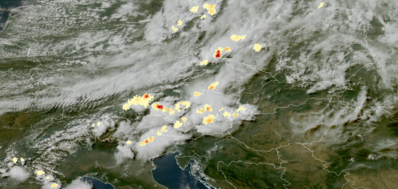
Convective storms captured by the MTG satellite on June 23, 2025, at 15:30 UTC. The yellow-red layer shows areas of lightning activity—the redder the color, the more lightning strikes were recorded. The background is a natural-color satellite image of cloud cover. Source: © EUMETSAT 2025, visualization: EUMETView
The study by scientists from the Institute of Atmospheric Physics focused on a detailed comparison of data from the Meteosat Third Generation satellite with the Earth Networks Total Lightning Network (ENTLN), a precise ground-based network. The research proved that the Lightning Imager exhibits higher detection sensitivity during nighttime hours compared to ground measurements. “In rare cases, these records may include optical phenomena unrelated to lightning activity, such as the passage of bright meteors (bolides) or intense lighting from large urban areas. During the day, on the other hand, detection is more difficult due to the higher light background caused by sunlight reflected off clouds, so some weaker discharges may not be captured,” describes the study’s author, Vojtěch Bližňák.
These findings are crucial for further improving the software that processes satellite data. “The goal is for the system to become even more efficient in the future at automatically recognizing and filtering false signals, providing meteorologists with the most reliable data possible on storm activity,” says Vojtěch Bližňák.
According to the Czech scientists, the new generation of Meteosat satellites is an important tool in both basic and applied research. Real-time lightning activity data is essential primarily for “nowcasting”—the very short-term forecasting of extreme weather events, such as hailstorms or torrential rainfall.
Contact: RNDr. Vojtěch Bližňák, Ph.D. Institute of Atmospheric Physics of the Czech Academy of Sciences bliznak@ufa.cas.cz +420 272 016 051
Link to the study: V. Bližňák and Z. Sokol (2026). First validation of the Lightning Imager aboard Meteosat Third Generation with Earth Networks Total Lightning Network. International Journal of Applied Earth Observation and Geoinformation, 147, 104273. https://doi.org/10.1016/j.jag.2026.105205